Additional Documents:
  
|
 |
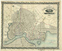
Map of the Consolidated City of Brooklyn
1863
A map is a representation of a whole or part of an area. This map represents the whole of Brooklyn at a certain point in time - 1863. The City of Brooklyn had grown rapidly, annexing the City of Williamsburgh and the towns of Bushwick and Greenpoint in 1854. The population swelled due to immigration from Ireland, Germany, and England. With the arrival of the steam ferry, people left dirty and congested Manhattan for a relatively uncrowded Brooklyn. The African-American population, though small, grew between 1830 and 1860, but not as fast as the overall population. The free Black communities of Weeksville and Carrsville thrived during this time. Business and industry prospered with great warehouses, docks, factories and stores rising along the river and in the downtown area of the city. Downtown Brooklyn was already crowded and people were beginning to move outwards from the city to what today we might call the suburbs. To move the people, horse railways and steam railways were built. By 1865, Brooklyn was the third largest city in America, after New York and Philadelphia. Nineteenth century views of the city of Brooklyn are often oriented with the East River at the bottom (with west at the top of the map), rather than with north at the top of the map.
To see a map of Brooklyn from 1700, view Document 1.
Citation - Document 51
1863
Brooklyn Public Library – Brooklyn Collection
www.brooklynpubliclibrary.org/civilwar
|
|